
Geography is associated with the memorization of geographical features (mountains, rivers, valleys, etc.) and the “simple” creation of maps, generally understood to be a true portrayal of reality, and not a representation created from a certain point of view. And on the other hand, geography was always considered strategic knowledge by States and capital in order to “make war.” According to radical geographer Lacoste, this went far beyond strictly “conducting military operations”: knowledge about space was associated with politics in a broader sense, being essential to know, organize and control space and the population over which the State apparatus exercised its authority. Lacoste's analysis shows us that geography's role in strengthening States and companies went beyond strategic knowledge: after its institutionalization as an academic and scholarly discipline in the nineteenth century, geography started to play a key role in the process of legitimizing the State's monopoly as land use planner in the collective imagination.
This perspective conceals an overall view of space, creating two distinct, yet closely related consequences. On the one hand, it has naturalized spatial configurations as givens (national borders and political-administrative divisions within States, for example), as if the formation of spaces were not political processes simultaneous to societal organization processes themselves. On the other hand, this concealment is responsible for creating a particular collective imagination that has naturalized the inherent linking of territory to the State; as if other groups/collectives were not also actors who appropriate and create space, as legitimate land use planners of their own living spaces and reproduction.
This powerful collective imagination began to be called into question in the 1970s (and more strongly in the following decades) both in academia (for which Lacoste's work was essential), and by social movements starting to organize based on new discursive strategies. Indigenous and Afro movements launched a mobilization for the recognition of cultural diversity, which brought to the surface the fact that nation-states—far from being homogenous cultural and territorial units—comprised a vast number of cultural particularities that were systematically trampled by state land use planning, which was criticized for destroying the lifestyles of different peoples. With a critical analysis of the hegemonic state model, these groups questioned the naturalization of the direct association between state, nation and territory, and in so doing sought to undo the founding myth of so-called “Modernity.”
Organized around demands for territory and autonomy, these movements made explicit that various forms of appropriation and land use exist, as well as different ways of relating to nature and organizing politically and economically; and through their struggles they tried to force the State to recognize their different geographies. Their demands directly confronted a colonialist model of development and social organization, proposing a rupture with colonialism's power and the knowledge that serves it, and proposing political, epistemic and territorial transformations.
Indigenous Latin American organizations—mainly in Ecuador, Bolivia, Mexico and Colombia—provide perhaps the most emblematic case of the change in discourse with respect to this imagination. By politicizing their identity and considering their different ethnicities as important, these peoples who had before self-identified as peasant farmers, radically changed their discourse and strategies. Thus, the old struggle for land broadened and transformed into a struggle for territory, self-determination and autonomy. However, the claim for cultural diversity within the nation-State—and its respective connection to territory—is not restricted to the indigenous movement; urban and black sectors, farmers, collectors (as in the case of rubber tappers in Brazil), among others, also began to organize in the 1980s, around a discourse that articulated recognition/respect for demands for territorial autonomy within nation-States.
In constant dialogue with these movements and with political science, geography also went through a period of critical rethinking, in which the supposed neutrality of academic and scholarly production began to be questioned. The “New Geography” of the Brazilian school, led by Milton Santos, Carlos Walter Porto Gonçalves and Rogério Haesbaert, broadened its understanding of the political and the territorial, so that it ceased to be tied exclusively to the State. Territorial and power relations began to be understood from a broader perspective, through the multiple subjects involved in space. Territory ceased to be under the State's monopoly, and geography became a tool to mark and demarcate land, and graph it in order to be materially and symbolically appropriated by subaltern groups, inseparable dimensions. Therefore, territory was not a pre-determined fact, but rather the result of a struggle of varying intensities and among different actors to appropriate a certain space, in continuous redefinition.
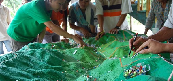
It is essential that social movements critically re-appropriate the concept of territory, as well as the strategy of “mapping” their territory in order to appropriate it, in the struggle against multiple dispossessions. From this perspective of critical geography, we believe that community mapping exercises can be tools for struggle and social transformation, as a way to build power among political subjects facing territorialization of capital in their living spaces; forge collective and individual imagination on the legitimacy of territorial appropriation in the face of the State and companies, and stimulate dialogue between younger generations and elders who have knowledge about territory, in a context of rural exodus.
It is essential to destroy the hierarchy of knowledge between people with degrees in geography and communities who create territory. The ultimate format of the resulting map will vary depending on its purpose: from mapping processes in which there is no actual map, to mental maps, maps with diagrams, artistic renditions/productions, life plans for counter land use planning, to Cartesian maps with all the legal requirements, etc. The map will depend on the scale of the demand and the organizational need. However, we must never forget that geography is always a weapon of war. Lacoste reminds us that with the best intensions, one may be providing the information most prized by the enemy. If mapping is conceived of as an end and not as a means, one runs the risk of providing a strong support to State and capitalist company planning strategies. Indeed, community mapping itself has been one of the tools most used by oil company community relations representatives, ministry officials interested in destroying indigenous territoriality, conservationist NGOs or capitalists who seek to implement tree plantations, to name some of the best known examples. Critical geography will be a contribution as long as it recognizes the dispute for territory among different political subjects, and chooses to place its tools in service of territorial appropriation of dispossessed peoples. From this perspective, community mapping can be a tactic to use.
Manuela Silveira y Manuel Bayón, geografiacriticaecuador@gmail.com
Colectivo de Geografía Crítica del Ecuador [Critical Geography Collective of Ecuador]
The complete original article is available here: https://geografiacriticaecuador.org/2016/04/10/mapeo-comunitario-geo-grafiando-para-la-resistencia/
Key works of critical geography, on which this text is based:
LACOSTE, Yves (1990 [1976]). La geografía: un arma para la guerra. Geography: a weapon of war Barcelona: Editorial Anagrama.
SANTOS, Milton (1978). Por una Geografía nueva. For a New Geography or Towards a New Geography São Paulo: Hucitec/EdUSP.
https://geografiacriticaecuador.files.wordpress.com/2013/01/santos-por-una-geografc3ada-nueva-completo.pdf
PORTO GONÇALVES, Carlos Walter (2003). Geografando nos varadouros do mundo. Brasília: IBAMA.
HAESBAERT, Rogério (2008) “Dos múltiplos territórios à multiterritorialidade”. In: HEIDRICH, Álvaro [et al.] (org). A emergência da multiterritorialidade: a ressignificação da relação do humano com o espaço. Canoas/Porto Alegre: Ed. ULBRA/EdUFGRS.